P2.15
Preliminary Results from Polar-Orbiting Satellite Data Assimilation into
LAPS with Application to Mesoscale Modeling of the San Francisco Bay Area
David A. Bennett*,
Keith D. Hutchison
Center for Remote Environmental Sensing Technology,
Lockheed Martin Missiles & Space
Sunnyvale, California
Steven C. Albers
NOAA Forecast Systems Laboratory, Boulder, Colorado
Also affiliated with CIRA (Cooperative Institute
for Research in the Atmosphere)
Robert D. Bornstein
San Jose State University, San Jose, California
1. INTRODUCTION
Lockheed Martin Missiles & Space (LMMS) is
pursuing research into the retrieval of advanced data products derived
from polar-orbiting meteorological satellites for enhanced mesoscale cloud
and moisture analyses and subsequent numerical weather prediction forecasts.
In cooperation with the Department of Meteorology at San Jose State University
and the National Oceanic and Atmospheric Administration's Forecast Systems
Laboratory (FSL), LMMS scientists at the Center for Remote Environmental
Sensing Technology (CREST) are evaluating the utility of high-resolution,
satellite-derived moisture data on mesocale forecasts. Moisture fields
retrieved from the Advanced Very High Resolution Radiometer (AVHRR) and
microwave moisture sounders are integrated into analysis and forecast fields
generated by the Local Analysis and Prediction System (LAPS), developed
by FSL, and the Fifth Generation Mesoscale Model (MM5), developed jointly
at the Pennsylvania State University (PSU) and the National Center for
Atmospheric Research (NCAR), respectively.
Modern computer technology developed in the last
decade makes it now feasible to fully utilize the volumes of remotely sensed
data collected from meteorological satellite systems in operational, mesoscale
forecast models. Early experience with the incorporation of remotely sensed
temperature profiles into large-scale numerical weather prediction models
demonstrated the importance of satellite data assimilation on forecast
accuracy. Along with global coverage, low earth orbiting satellites have
the advantage of being able to carry microwave instruments. Retrieval in
the microwave spectral region is critical to obtaining the vertical structure
of atmospheric temperature and water vapor.
This paper gives a brief description of the LAPS
system as implemented in CREST and shows preliminary results from AVHRR
visible and infrared data assimilation into the LAPS cloud analysis. It
also discusses both the retrieval of remotely sensed cloud analyses from
spectral signatures in multiple sensors carried by polar-orbiting meteorological
satellites, and a new approach to incorporate these data into both LAPS
and MM5 mesoscale models. The impact of these data on mesoscale forecasts
will be presented in a future paper.
2. IMPLEMENTATION OF LAPS IN CREST
LAPS is a fully integrated, meso-beta-scale data
assimilation and analysis system designed to handle all types of meteorological
observations (described by McGinley 1989 and McGinley et al. 1992). It
uses an effective analysis scheme to harmonize high resolution temporal
and spatial data onto a regular grid, producing hourly surface and upper
air atmospheric variables that can be used by operational forecasters to
both assess current conditions and provide initial or boundary conditions
for a local forecast model.
The LAPS cloud analysis (described in Albers et
al. 1996), uses 10.8m infrared, and 0.62m visible satellite data, surface
observations, aircraft reports and radar data, along with model first guess
fields. Consistent three-dimensional cloud water and cloud ice analyses
are derived using a modified Smith-Feddes (Haines et al. 1989) model. For
each gridpoint with a cloud fraction > 0.65, cloud liquid water and cloud
ice are analyzed. For thin clouds with a fraction of < 0.65, cloud condensate
is estimated by considering cloud drop/ice crystal diameter and optical
cross-section. LAPS is being configured in CREST to use polar-orbiting
satellite data to augment the data stream while providing valuable cloud
cover and vertical structure information to improve subsequent analyses.
The CREST laboratory was established in 1990 to
serve as a testbed for satellite data retrieval algorithms and data processing
for polar-orbiting satellites. The primary function of CREST is to support
the National Polar-orbiting Operational Environmental Satellite System
(NPOESS) program with the development of the Integrated Weather Product
Testbed (IWPTB). The CREST Lab computer network consists of 13 UNIX workstations,
eight of these are Dec-alphas running Digital UNIX 4.0d. A variety of forward
models, sensor models, satellite hardware models, and retrieval algorithms
are also resident in CREST providing system engineers with the capability
to perform end-to-end system-level simulations. Visualization environments
include but are not limited to: Vis5d, NCAR Graphics, IDL, and an extensive
network of AVS/Express modules.
LAPS is currently running its ingest and analysis
functions on a 400mhz Dec-Alpha workstation with 1 GB of RAM. The LAPS
fields reside on a 100 x 80, 10km horizontal resolution domain centered
on Sunnyvale, California, with 21 isobaric levels at 50 mb vertical spacing.
The LAPS domain and local terrain are shown in Fig.
1.
The tracking, ingest, and processing of satellite
data are performed automatically and in real time using NOAA-12, 14 and
15 data collected by the CREST High Resolution Picture Transmission (HRPT)
ground station. A 1-km resolution, 1024 x 1024 pixel scene of AVHRR imagery,
with 10-bit accuracy, is navigated from a full swath of each pass. Automated
cloud analysis algorithms (Hutchison et al. 1995, 1997) are executed on
this intermediate dataset which consists of calibrated imagery, TOVS, and
orbital data. These automated algorithms employ threshold functions that
vary with environmental conditions in which a cloud is found, i.e., functions
vary with solar zenith angle and scattering phase functions for visible
and near-IR channels and with total integrated water vapor for long-wave
IR channels. Software has been developed to geolocate and register these
cross sensor data with each other, and to the LAPS grid. Discussions here
are with standard visible 0.62m and infrared 10.8m AVHRR data in place
of GOES data normally used in the LAPS analysis system. To make use of
the LAPS moisture fields in MM5, the LAPS analysis containing satellite
data is used as the first boundary condition. The remaining boundary conditions
are provided by the Eta model with the initial conditions provided by a
previous LAPS analysis.
3. APPROACH
Some regions of the U.S. enjoy data-rich environments,
including extensive profiler, surface, and Doppler radar networks. One
of these regions is Colorado where LAPS has been running operationally
at FSL for nearly ten years. It is suggested that polar-orbiting data,
especially microwave sounding data, can provide high spatial and (with
several satellites) high temporal resolution of both temperature and moisture
profiles, as well as cloud cover and cloud type information into both LAPS
and any forecast model. This type of system can be particularly useful
in areas that do not have profiler networks and in polar regions, where
satellite passes are frequent but surface data are sparse.
The LAPS moisture analysis (Birkenheuer 1994)
also depends heavily on satellite data, as well as on surface data. Satellite
retrievals also provide estimates of total precipitable water. With knowledge
of the near surface moisture and its vertical distribution defined by the
background field, moisture can be partitioned into vertical layers. Also
contributing is the cloud analysis output which can further identify saturated
air and thus contribute to better definition of the moisture field (Birkenheuer
1996).
Architecture has been developed to make use of
imagery data, microwave data and infrared sounder data from polar-orbiting
satellites to derive high resolution cloud characteristics. This dataset
consists of single sensor products, such as imagery and temperature profiles,
and cross sensor products, such as cloud mask and cloud top height. These
products when combined into a single database have the potential to provide
valuable cloud and moisture information for atmospheric analysis and forecasts.
For example, infrared sounder data when combined with imagery can provide
cloud location and layer information which can then be combined with microwave
data to evaluate cloud base height. Several intermediate products of this
type (e.g. cloud top pressure, cloud top height, cloud mask and total integrated
water vapor, etc.) are produced with each TIROS pass in CREST. Enhancements
to existing analysis algorithms will be needed so they can accept the new
intermediate products as input.
4. CASE STUDY
The case study presented is 2300 UTC Thursday
05 August 1999. The satellite data are from a NOAA-14 pass, with a peak
elevation of 87.75° . The Channel 1 (0.62m ) and Channel 4 (10.8m )
calibrated imagery was geolocated to the LAPS grid. Each pixel value was
then averaged with the eight surrounding pixels to provide slightly smoother
brightness temperature and albedo values on the much coarser LAPS grid.
The Eta 1200 UTC run provides the first guess fields with METAR surface
observations used to provide valuable sky cover information. The synoptic
pattern included a summertime cut-off low at 500 mb, which usually provides
interesting vertical and horizontal cloud structure. Low stratus along
the central California coast, midlevel altocumulus, cumulus and cirrus
are all present in the image. Fig.
2 shows a false color enhanced satellite image using the 0.87m , 10.8m
and 12.0m channels. This type of enhancement is used to highlight the spectral
characteristics of the cloud and land features. The 0.87m channel has both
thermal and visible characteristics that help to distinguish between land
and water while the 10.8m and 12.0m channels are used to distinguish optically
thin cirrus clouds from low and midlevel optically thicker clouds. Fig.
3 shows the LAPS column maximum cloud cover (lcv) product derived from
the 3-D cloud analysis. Comparing Fig.
2 and Fig. 3 shows
that LAPS makes positive use of AVHRR brightness temperature and albedo
values. Fig. 4 shows the final
LAPS 3D analysis. The fields displayed are surface air temperature over
terrain, surface winds, cloud liquid water (light blue) and cloud ice (white).
Note the lower altocumulus clouds off-shore that have been analyzed as
liquid water. Preliminary results from this case and others observed show
that the analyzed cloud bases and heights are consistent with satellite
imagery. This is especially true in regions of higher albedo values. Lower
isosurface threshold values of cloud fraction often give a better depiction
of the actual cloud field using AVHRR data for this region.
5. CONCLUSION
This paper presents the system in CREST into which
LAPS is implemented to interface with polar orbiting satellite data. The
case presented here shows positive preliminary results in including infrared
and visible AVHRR data to augment the LAPS cloud analysis. The architecture
for developing a database of remotely sensed, multisensor data has been
presented. Future plans are to extend this database to include Earth Observing
Satellite (EOS) and NPOESS class sensor data.
Architecture that will implement the more complex
cloud properties from polar-orbiting satellites into LAPS will need further
development, but preliminary results to contribute useful cloud and moisture
information from polar orbiting satellites into LAPS and any mesoscale
model are encouraging.
6. REFERENCES
Albers S., J. McGinley, D. Birkenheuer, J. Smart,
1996: The Local Analysis and Prediction System (LAPS): analyses of clouds,
precipitation, and temperature.
Wea. and Forecasting, 11, 273-287.
Birkenheuer, D.L., 1992: The LAPS specific humidity
analysis. NOAA Tech. Memo. ERL FSL-1, NTIS, 5285 Port Royal Rd.,
Springfield, VA 22061
Birkenheuer, D., 1996: Exploiting available satellite
data in AWIPS-era workstations. Preprints, Eighth Conf. on Satellite
Meteorology. Atlanta, GA. Amer. Meteor. Soc., 46-49.
Haines, P. A., J.K. Luers, and C.A. Cerbus, 1989:
The role of the Smith-Feddes model in improving the forecasting of aircraft
icing. Preprints, Third Conf. on Aviation Weather Systems, Anaheim,
Cal, Amer. Meteor. Soc., 258-263.
Hutchison, K. D., Etherton, B. J., Topping, P.
C., and A. H. L. Huang, 1997: Cloud top phase determination from the fusion
of signatures in daytime AVHRR imagery and HIRS data, International
Journal of Remote Sensing, 18, 3245-3262
Hutchison, K. D. and K. Hardy, 1995: Threshold
functions for automated cloud analysis of global meteorological satellite
imagery. International Journal of Remote Sensing, 16, 3665-3680
McGinley, J.A., S.C. Albers, and P.A. Stamus,
1992: Local data assimilation and analysis for nowcasting. Adv. Space
Res., Great Britain, 12, no. 7, 179-188.
McGinley, J.A., 1989: The Local Analysis and Prediction
System. Preprints of the 12th Conference on Weather Analysis and Forecasting,
October 2-6, 1989, Monterey, CA, American Meteorological Society, 15-20.
Wilheit, T. T. and K. D. Hutchison, Retrieval
of cloud base heights from passive microwave and cloud top temperature
data. (Accepted for publication by the IEEE Transactions on Geoscience
and Remote Sensing)
* Corresponding
author address: David A. Bennett, Lockheed Martin Missiles and Space,
1111 Lockheed Martin Way, Bd. 107, Sunnyvale CA 94089; e-mail: david.a.bennett@lmco.com
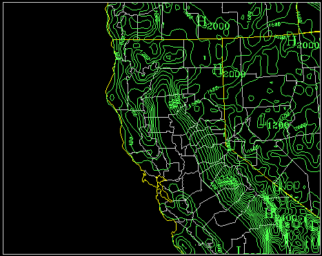
Figure 1. LAPS California domain and terrain
elevation (m).
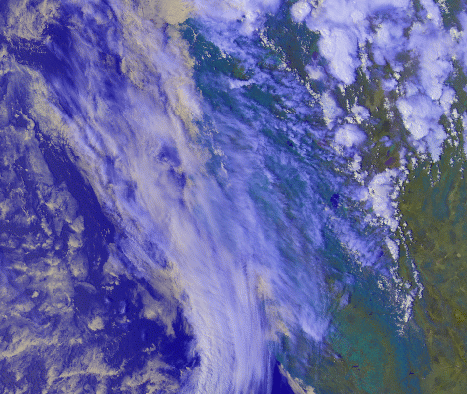
Figure 2. NOAA-14 AVHRR false color composite
image using 0.87m , 10.8m , and 12.0m bands.
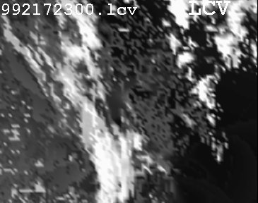
Figure 3. LAPS column maximum cloud cover
values (lcv) for 2300 UTC 05 August 1999.
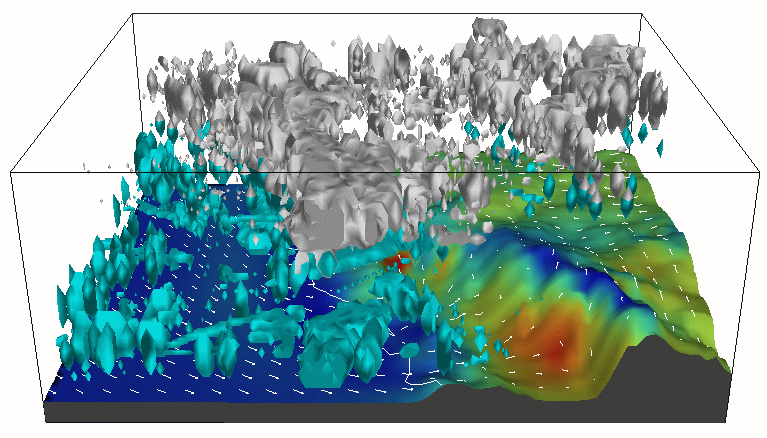
Figure 4. Final LAPS 3D analysis of cloud
liquid water (lt. blue), cloud ice (white), surface winds (white vectors)
and surface air temperature (surface color shading). The California coastline
is also drawn white.